
Pixxel
Documentation
Developer Guide
Pixxel API
Overview
About PixxelPixxel's ConstellationPixxel's Tech Demonstrators

Getting Started
AuroraQuick Start

Bandsets Overview
Understanding HSI and MSI BandsetsSpectral Bandsets (Spectral Indices)
Product Walkthrough

Tasking
Tasking Basics

Available BandsetsCustom Bandsets
Ordering and Cart
Archive OrderingWorking with CartOrder Listing, Status and Details
Catalog and Delivery
My CatalogExport ImageryNaming Convention
Explore Images & Create AOIs
ExploreSearch Location and Draw/Upload AOISearch and Select ImagesSatellite DataAOI Info and Scenes
Analytics Tools

OverviewPreset Indices & Custom Indices

List of IndicesNDVI (Normalized Difference Vegetation Index)NDWI GREEN (Normalized Difference Water Index Green)NDWI (Normalized Difference Water Index)NDBI (Normalized Difference Built-up Index)VARI (Visible Atmospherically Resistant Index)NBRI (Normalized Burn Ratio Index)SAVI (Soil Adjusted Vegetation Index)RedEdge2NDDI (Normalized Difference Drought Index)MTVI (Modified Triangular Vegetation Index 2)TVI (Transformed Vegetation Index)NDRE (Normalized Difference RedEdge)TCARI (Transformed Chlorophyll Absorption Ratio Index)MSAVI (Modified Soil Adjusted Vegetation Index)RECI (Red Edge Chlorophyll Index)NDMI (Normalized Difference Moisture Index)GNDVI (Green Normalized Difference Vegetation Index)SIPI (Structure Intensive Pigment Index)GRVI (Green Normalized Difference Vegetation Index)PSRI (Plant Senescence Reflectance Index)GCI (Green Chlorophyll Index)CVI (Chlorophyll Vegetation Index)MSI (Moisture Stress Index)MTCI (MERIS Terrestrial Chlorophyll Index )NDSI (Normalized Difference Snow Index)OSI (Oil Spill Index)NDVI 705 (Normalized Difference Snow Index)RENDVI (Red Edge NDVI Index)SI (Salinity Index)REIP (Red Edge Inflection Point Index)NMDI_SOIL (Normalized Multi-band Drought Index for Soil)NMDI_VEG (Normalized Multi-band Drought Index for Vegetation)ARI (Anthocyanin Reflectance Index)ARI2 (Anthocyanin Reflectance Index)GEMI (Global Environmental Monitoring Index)CMI (Clay Mineral Index)EVI (Enhanced Vegetation Index )EVI2 (Enhanced Vegetation Index 2 )FMI (Ferrous Mineral Index)IOI (Iron Oxide Index)CI (Cyanobacteria Index)NDCI (Normalized Difference Chlorophyll Index)CCCI (Canopy Chlorophyll Content Index Index)FAI (Floating Algae Index)MCARI (Modified Chlorophyll Absorption Ratio Index)MCI (Maximum CHlorophyll Index)MNDWI (Modified Normalized Difference Water Index)CRI1 (Carotenoid Reflectance Index 1)CRI2 (Carotenoid Reflectance Index 2)PRI (Photochemical Reflectance Index)
Bands
Spectral SignatureSplit Compare
Analytical Models
Insights in Aurora (AOI Screen)Model Marketplace

Workflows
Workflow and Jobs
Aurora Intelligence
OverviewImage SearchChat HistoryIndices Creation
Legal Documents
Third Party Satellite Provider Documents
Pixxel
Documentation
Developer Guide
Pixxel API
Overview
About PixxelPixxel's ConstellationPixxel's Tech Demonstrators

Getting Started
AuroraQuick Start

Bandsets Overview
Understanding HSI and MSI BandsetsSpectral Bandsets (Spectral Indices)
Product Walkthrough

Tasking
Tasking Basics

Available BandsetsCustom Bandsets
Ordering and Cart
Archive OrderingWorking with CartOrder Listing, Status and Details
Catalog and Delivery
My CatalogExport ImageryNaming Convention
Explore Images & Create AOIs
ExploreSearch Location and Draw/Upload AOISearch and Select ImagesSatellite DataAOI Info and Scenes
Analytics Tools

OverviewPreset Indices & Custom Indices

List of IndicesNDVI (Normalized Difference Vegetation Index)NDWI GREEN (Normalized Difference Water Index Green)NDWI (Normalized Difference Water Index)NDBI (Normalized Difference Built-up Index)VARI (Visible Atmospherically Resistant Index)NBRI (Normalized Burn Ratio Index)SAVI (Soil Adjusted Vegetation Index)RedEdge2NDDI (Normalized Difference Drought Index)MTVI (Modified Triangular Vegetation Index 2)TVI (Transformed Vegetation Index)NDRE (Normalized Difference RedEdge)TCARI (Transformed Chlorophyll Absorption Ratio Index)MSAVI (Modified Soil Adjusted Vegetation Index)RECI (Red Edge Chlorophyll Index)NDMI (Normalized Difference Moisture Index)GNDVI (Green Normalized Difference Vegetation Index)SIPI (Structure Intensive Pigment Index)GRVI (Green Normalized Difference Vegetation Index)PSRI (Plant Senescence Reflectance Index)GCI (Green Chlorophyll Index)CVI (Chlorophyll Vegetation Index)MSI (Moisture Stress Index)MTCI (MERIS Terrestrial Chlorophyll Index )NDSI (Normalized Difference Snow Index)OSI (Oil Spill Index)NDVI 705 (Normalized Difference Snow Index)RENDVI (Red Edge NDVI Index)SI (Salinity Index)REIP (Red Edge Inflection Point Index)NMDI_SOIL (Normalized Multi-band Drought Index for Soil)NMDI_VEG (Normalized Multi-band Drought Index for Vegetation)ARI (Anthocyanin Reflectance Index)ARI2 (Anthocyanin Reflectance Index)GEMI (Global Environmental Monitoring Index)CMI (Clay Mineral Index)EVI (Enhanced Vegetation Index )EVI2 (Enhanced Vegetation Index 2 )FMI (Ferrous Mineral Index)IOI (Iron Oxide Index)CI (Cyanobacteria Index)NDCI (Normalized Difference Chlorophyll Index)CCCI (Canopy Chlorophyll Content Index Index)FAI (Floating Algae Index)MCARI (Modified Chlorophyll Absorption Ratio Index)MCI (Maximum CHlorophyll Index)MNDWI (Modified Normalized Difference Water Index)CRI1 (Carotenoid Reflectance Index 1)CRI2 (Carotenoid Reflectance Index 2)PRI (Photochemical Reflectance Index)
Bands
Spectral SignatureSplit Compare
Analytical Models
Insights in Aurora (AOI Screen)Model Marketplace

Workflows
Workflow and Jobs
Aurora Intelligence
OverviewImage SearchChat HistoryIndices Creation
Legal Documents
Third Party Satellite Provider Documents
  1. Analytics Tools
  2. Visualizations
  3. Available Indices
  4. SAVI (Soil Adjusted Vegetation Index)

SAVI (Soil Adjusted Vegetation Index)

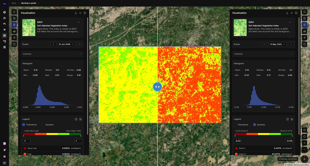
The Soil Adjusted Vegetation Index (SAVI) is a spectral index used in remote sensing to estimate the vegetation greenness in an area. It takes into account the impact of soil optical properties on the measurement of vegetation. The SAVI is calculated using the normalized difference vegetation index (NDVI) and adding the soil reflectance. The result ranges from 0 to 1, where 1 indicates perfect vegetation cover and 0 indicates bare soil. The SAVI is useful for monitoring crop growth, detecting changes in vegetation cover, and estimating biomass.

Sentinel = 1.5*((B08-B04)/(B08+B04+0.5))
Landsat 8-9 = 1.5*((nir08-red)/(nir08+red+0.5))
Firefly = 1.5*((B118-B062)/(B118+B062+0.5))
NBRI (Normalized Burn Ratio Index)RedEdge2