Documentation Index
Fetch the complete documentation index at: https://docs.pixxel.space/llms.txt
Use this file to discover all available pages before exploring further.
Satellite Data : Sentinel-2 [Multispectral]
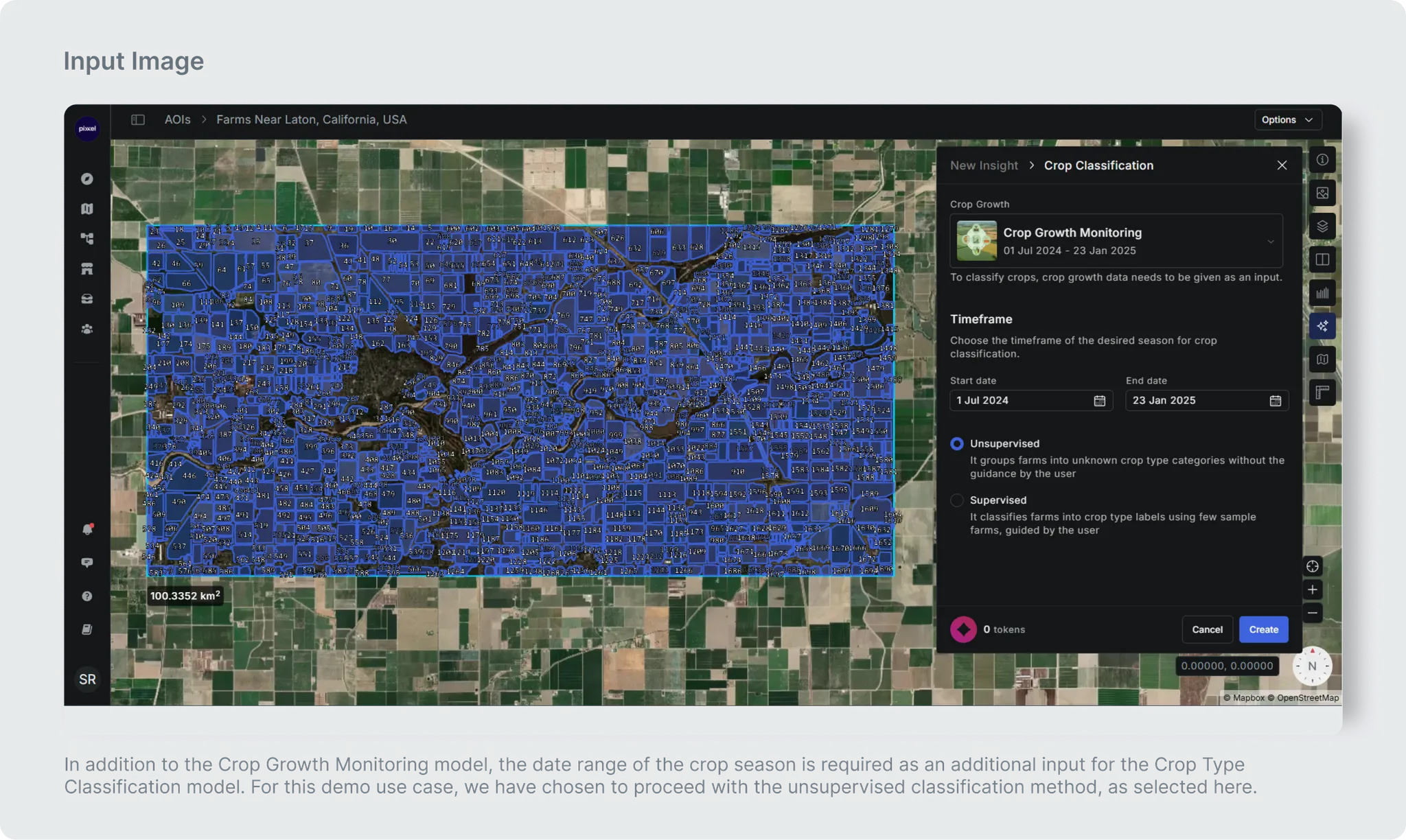
Crop classification model identifies the crops grown in the given farm in an area of interest (AOI). There are 2 variants of this model:
- Supervised Classification: This variant requires reference crop names (labeled data), guided by the user for a few farms within the area of interest (AOI). The model uses this labeled data to classify other farms within the same AOI as per the provided crop names. This variant of the model not only assigns labels to each farm but also provides confidence levels for the predictions. These confidence levels are categorized as high (>75%), medium (60-75%), or low (< 60%). The variant also handles the scenario in which crop labels are provided for a few crops but missing for some crops. For example, if there are 10 crops in an AOI but information is provided for only 5 crops (Cotton, Chilly, Tomato, Cabbage, Beans), the model labels these 5 crops and assigns general labels such as Crop Type #1, Crop Type #2, and so on for the remaining crops; ensuring comprehensive classification across the entire AOI.
- Unsupervised Classification: This variant does not require any reference crop information as input. This variant of the model automatically identifies the number of distinct crops without the confidence level in the area of interest(AOI) and accordingly assigns a generic class to each farm such as Crop Type 1, Crop Type 2, and so on.
Potential Applications
- Precision Agriculture: Enables farmers to manage crops more efficiently by mapping where different crops are grown. This leads to smarter application of fertilizers, pesticides, and water, reduces waste, and improves overall yield and sustainability by addressing specific needs of each crop or field at the right time.
- Yield Estimation and Forecasting: Improves the accuracy of predicting harvest quantities by integrating crop type maps with historical yields and weather data. This supports better market planning, food supply management, and early warning for issues like drought or pest outbreaks, aiding risk management for growers and buyers.
- Crop Insurance and Risk Assessment: Helps insurers quickly and accurately verify crop types and acreage after natural disasters or pest infestations. This streamlines claims processing, improves transparency, and allows for more precise risk assessment and financial planning in agricultural insurance.
- Policy and Land Use Planning: Provides government agencies and planners with reliable data for policy-making, subsidy allocation, and land use regulation. Accurate crop classification informs sustainable development strategies and helps balance agriculture with conservation or urban expansion needs.
USE CASE 1 [Via Unsupervised Classification]
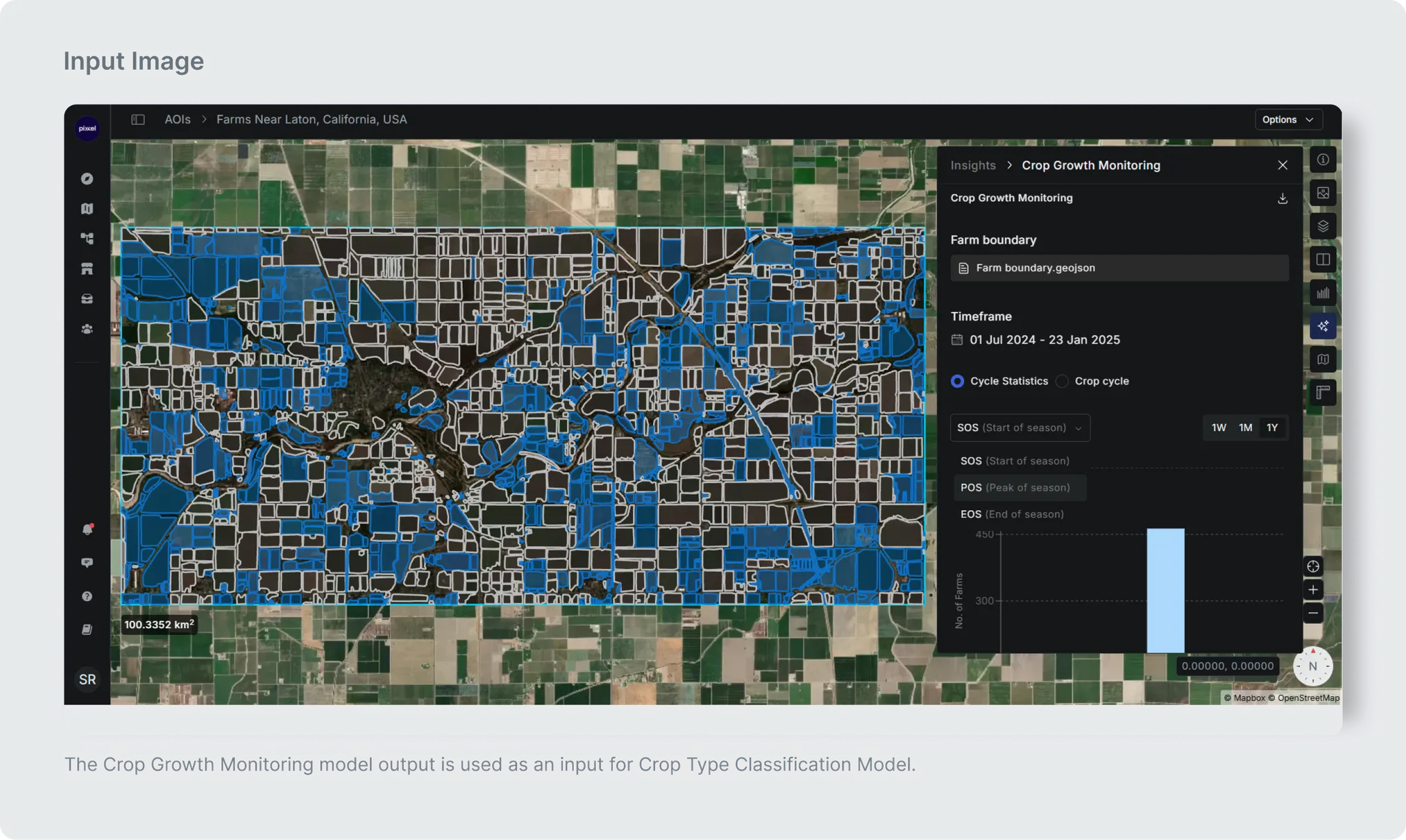
The Model takes output of the Crop Growth Monitoring model as Input, and a date range for the crop season.
So following inputs are required by this model:
| Name | Description |
|---|
| Crop Phenological Metrics | Output generated by the Crop Growth Monitoring model to use Temporal NDVI data and phenometrics corresponding to each farm boundary as input to this model. |
| Start date of crop season | Start date of crop season in “YYYY-MM-DD” format |
| End date of crop season | End date of crop season in “YYYY-MM-DD” format |
 Important Guidelines
These are the basic guidelines before running the model:
Important Guidelines
These are the basic guidelines before running the model:
- Given date range of Crop Season should not be more than one year.
- Please select the date range (start_date and end_date) corresponding to the crop season of the selected area.
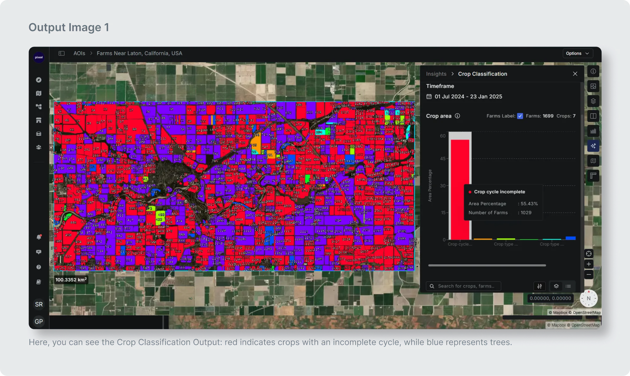
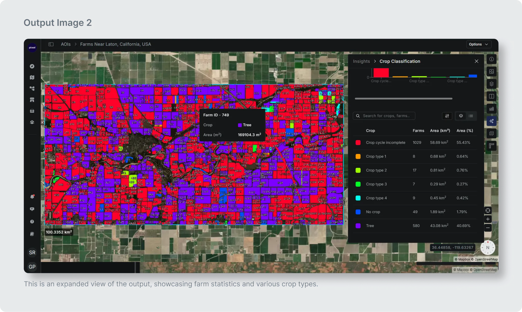
Output
The model generate two types of outputs: i.e. Crop Classification map and its statistics.
| Name | Description | Download output as |
|---|
| Crop Classification Map | This map shows the identified crop type corresponding to each farm in the AOI. | .geojson (vector format) |
| Statistics for Crop Classification Map | Derived crop statistics like, total area for each predicted crop type name. | .csv (tabular format) |
Classified Map Attributes or Crop Classification Map Attributes [Downloadable as .geojson]
The classified map includes not only the map attributes but also crop pheno-metrics corresponding to each crop-labeled farm. These pheno-metrics include:
- SOS (Start of Season): The sown date or when planting begins.
- EOS (End of Season): The harvested date or when harvesting occurs.
- Durations: The length of the growing season from sowing to harvest.
- Cycle: The position of the crop within different crop growth cycles.
- Peak NDVI: The highest Normalized Difference Vegetation Index value, indicating the peak vegetation health and density during the growth cycle. The table below presents attributes specific to the crop map.
These are the map attributes additionally provided here in the .geojson file.
| Attribute | Description |
|---|
| Farm_ID | ID of each selected farm |
| Predict label | Model Predicted Crop Label for corresponding farm ID |
| Reference label (If reference crop is given) | Crop label corresponding to already known farm |
| Confidence (If reference crop is given) | Confidence of predicted crop label Which are categorized into High, Medium and Low categories |
Statistics table attributes of Crop Classification Map [Second Output]
The statistics table will have 3 attributes :
| Attribute | Description |
|---|
| Predict label | Crop Label predicted by model |
| Area in sq. km. | Area (sq. km.) corresponding to predicted label |
| Farm count | Count of farm corresponding to each predicted label |
| Color code | Unique color code corresponding to predicted label |
USE CASE 2 [Via Supervised Classification]
The Model takes output of the Crop Growth Monitoring model as Input, and a date range for the crop season. [Note: The given date range of the crop season should not be more than one year.]
Following inputs are required by this model:
| Name | Description |
|---|
| Crop Phenological Metrics | Output generated by the Crop Growth Monitoring model to use Temporal NDVI data and phenometrics corresponding to each farm boundary as input to this model. |
| Start date of crop season | Start date of crop season in “YYYY-MM-DD” format |
| End date of crop season | End date of crop season in “YYYY-MM-DD” format |
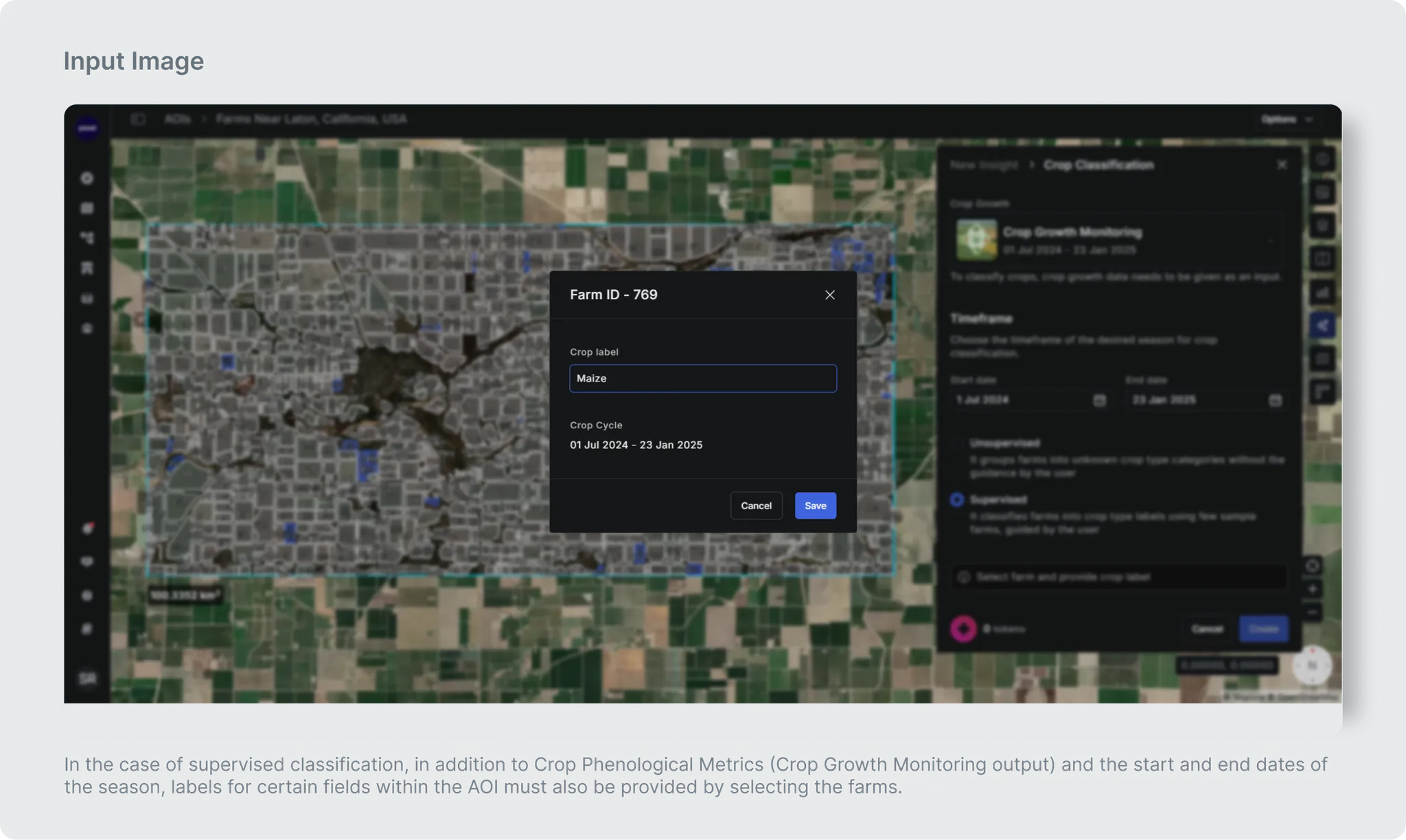
| Labels for some fields in the AOI ( incase of Supervised Classification) | The user needs to select farms and assign the corresponding crop label to each farm ID for specific fields within the AOI. |

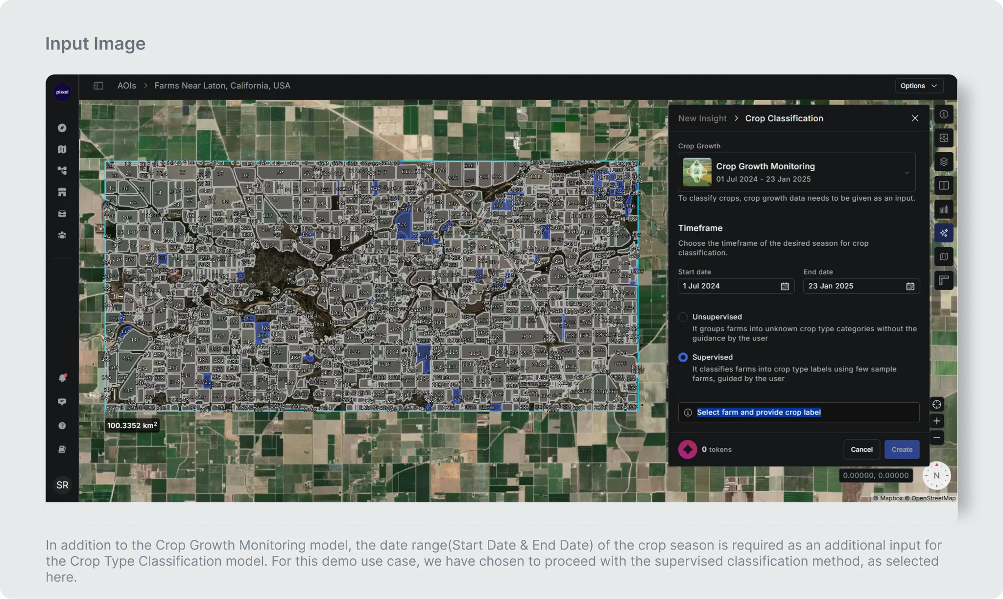 Important Guidelines
These are the basic guidelines before running the model:
Important Guidelines
These are the basic guidelines before running the model:
- Given date range of Crop Season should not be more than one year.
- Please select the date range (start_date and end_date) corresponding to the crop season of the selected area.
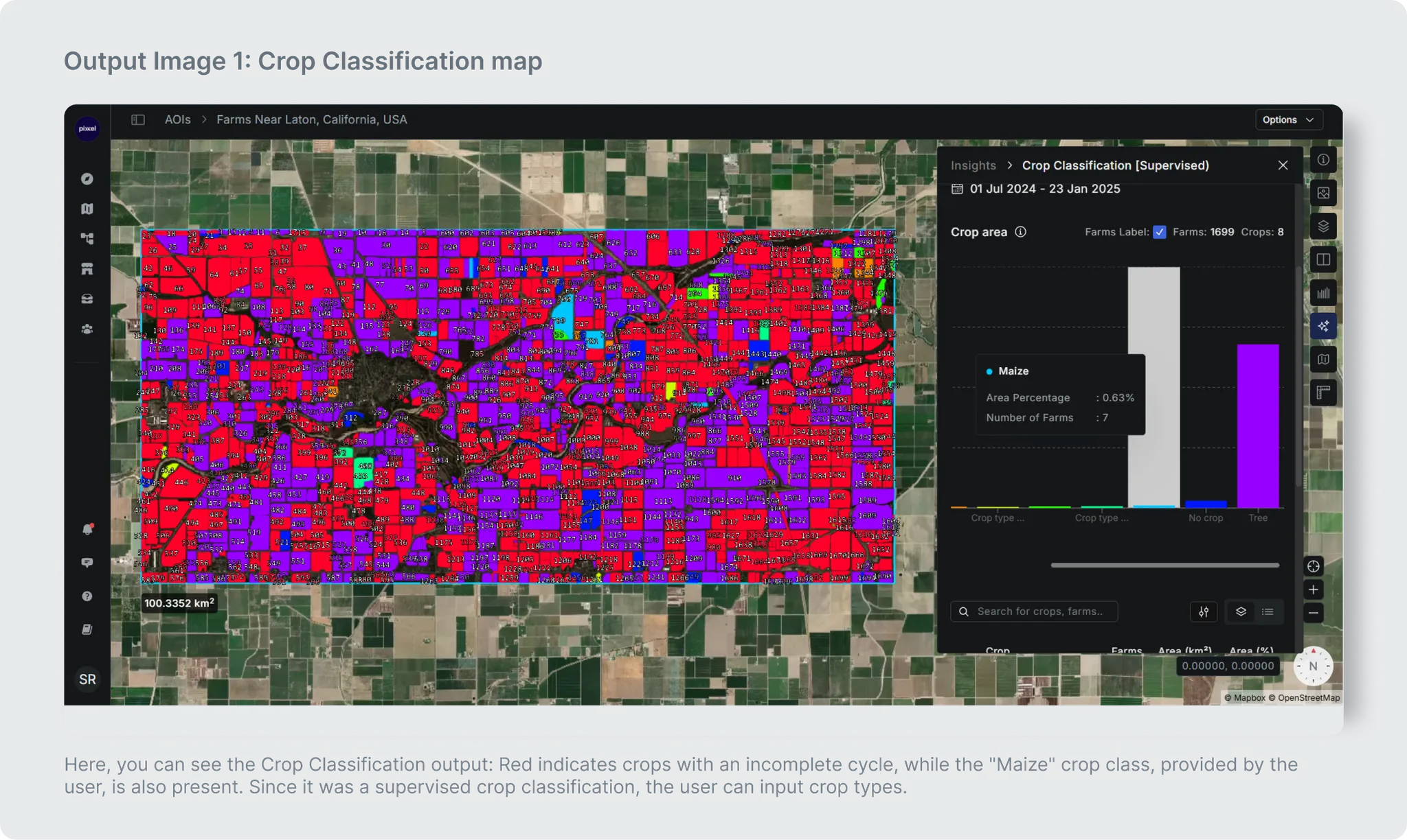
Output
Similar to previous demo, the model generate two types of outputs: i.e. Crop Classification map and its statistics.
| Name | Description | Download output as |
|---|
| Crop Classification Map | This map shows the identified crop corresponding to each farm in the AOI | .geojson (vector format) |
| Statistics for Crop Classification Map | Derived Crop statistics like, total area for each predicted crop type name. | .csv (tabular format) |
Classified Map or Crop Classification Map Attributes [Downloadable as .geojson]
The classified map includes not only the map attributes but also crop pheno-metrics corresponding to each crop-labeled farm. These pheno-metrics include:
- SOS (Start of Season): The sown date or when planting begins.
- EOS (End of Season): The harvested date or when harvesting occurs.
- Durations: The length of the growing season from sowing to harvest.
- Cycle: The position of the crop within different crop growth cycles.
- Peak NDVI: The highest Normalized Difference Vegetation Index value, indicating the peak vegetation health and density during the growth cycle. The table below presents attributes specific to the crop map.
These are the map attributes additionally provided here in the .geojson file.
| Attribute | Description |
|---|
| Farm_ID | ID of each selected farm |
| Predict label | Model Predicted Crop Label for corresponding farm ID |
| Reference label (If reference crop is given) | Crop label corresponding to already known farm |
| Confidence (If reference crop is given) | Confidence of predicted crop label Which are categorized into High, Medium and Low categories |
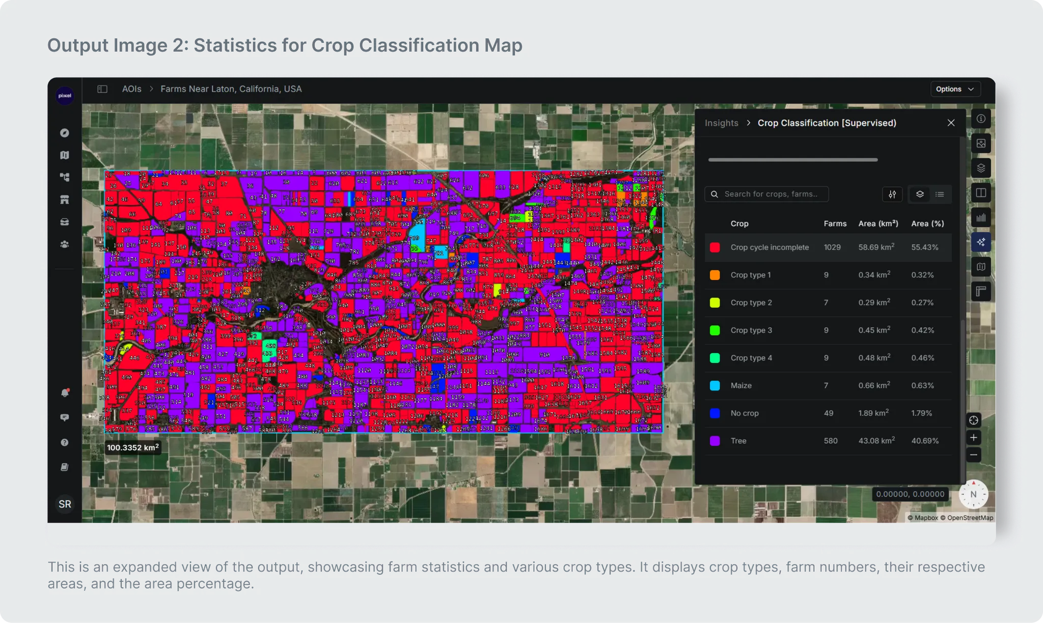
Statistics table attributes of Crop Classification Map [Second Output]
The statistics table will have 3 attributes :
| Attribute | Description |
|---|
| Predict label | Crop Label predicted by model |
| Area in sq. km. | Area (sq. km.) corresponding to predicted label |
| Farm count | Count of farm corresponding to each predicted label |
| Color code | Unique color code corresponding to predicted label |
Expected Model Run Time
| AOI Size Range (in sq km) | Estimated Model Run Time |
|---|
| 0 to 500 | 6 Minute |
| 500 to 1000 | 15 Minutes |
| 1000 to 1500 | 22 Minutes |
| 1500 to 2500 | 35 Minutes |
| 2500 to 5000 | 40 Minutes |
Additional details
Minimum size of Area of Interest required (in Sq KMs.): No restrictions
Maximum size of Area of Interest supported (in Sq KMs.): 5000
Geographies supported: All geographies
Model Accuracy:
| Overall Accuracy (Supervised classification) | Overall Accuracy (Unsupervised classification) |
|---|
| 65 to 79 % | 56 to 62 % |
- The model identifies the crop for the most recent complete crop cycle.
- The model does not identify crops for farms with crop cycles lasting over a year.
- Analysis is limited to the latest single season.