
Indices Creation
Aurora Intelligence simplifies geospatial analysis by enabling users to generate spectral indices using natural language. Instead of manually selecting analytical tools, configuring parameters, and navigating complex workflows, users can simply describe the analysis they want to perform on an Area of Interest (AOI).
By leveraging natural language commands, users can request vegetation, water, urban, burn severity, and other index-based analyses directly from the chat interface. Aurora Intelligence automatically identifies the appropriate index based on the type of land and the indices that can be run on it, performs the computation on the selected AOI, and visualizes the results for further exploration.
How It Works
-
Select an Area of Interest (AOI) – Choose an existing AOI or create a new AOI using Aurora Intelligence.
-
Request an Analysis – Specify the index or describe the analytical outcome you want to achieve.
-
Generate Results – Aurora Intelligence runs the appropriate index on the selected AOI and displays the resulting layer on the map.
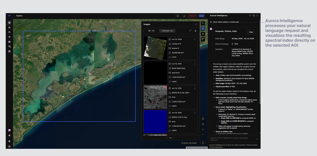
Examples:
- Show NDVI for the selected AOI.
- Calculate NDWI for Bellandur Lake.
- Show vegetation health for the selected area.
- Identify burned regions in this AOI.
- Show water bodies in Chilika Lake.
Required parameters:
The user needs to specify an AOI to perform index generation, as it is a mandatory requirement. The AOI can either be selected from the map or created through Aurora Intelligence. The user should also specify additional parameters such as:
- Index: Users can directly specify the index they want to generate, such as NDVI, NDWI, NDBI, NBR, SAVI, and other supported indices.
- Analysis Objective: Instead of specifying an index name, users can describe the outcome they are looking for. For example, "show healthy vegetation", "identify water bodies", "detect urban regions", or "analyze burned areas". Aurora Intelligence automatically selects the most appropriate index for the requested analysis.
- Time: Users can specify a time period for the analysis using exact dates or date ranges.
- Cloud Cover: Users can specify cloud cover constraints to ensure the analysis is performed on suitable imagery. They may use phrases such as "cloud free", "clear imagery", "less than 20% cloud cover", or similar variations.